


La Rosière Mille Étangs 26 mai 2019 OVS

TRIMAILLE
User
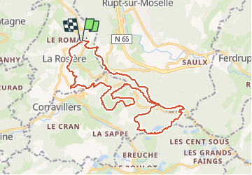

Length
21 km

Max alt
750 m

Uphill gradient
584 m
Km-Effort
29 km

Min alt
556 m

Downhill gradient
601 m
Boucle
Yes
Creation date :
2019-05-26 08:39:06.995
Updated on :
2019-12-16 18:00:36.398
6h18
Difficulty : Difficult

FREE GPS app for hiking
 SityTrail
IGN / Geographical institutes
SityTrail Plus
The world is yours!
About
Trail Walking of 21 km to be discovered at Bourgogne-Franche-Comté, Haute-Saône, La Rosière. This trail is proposed by TRIMAILLE.
Positioning
Country:
France
Region :
Bourgogne-Franche-Comté
Department/Province :
Haute-Saône
Municipality :
La Rosière
Location:
Unknown
Start:(Dec)
Start:(UTM)
323229 ; 5309428 (32T) N.
Comments